
John Agar
Managing Director
Service
Highly accurate state-of-the-art laser and photographic equipment used to produce cross-platform models and photo tours that give instant online access to strategic site information.
The surveyed 3D co-ordinates of the camera location and "in the view" building and feature information is used to control the photo alignment. 3D AutoCAD models and line work are then used to test the alignment. A model of the proposal is inserted into the image in the correct location and scale, allowing the impact of the proposal to be fully assessed.
MSA is recognised as the leader in this field having been previously appointed by the GLA to survey the assessment points for, and consult on, the LVMF.
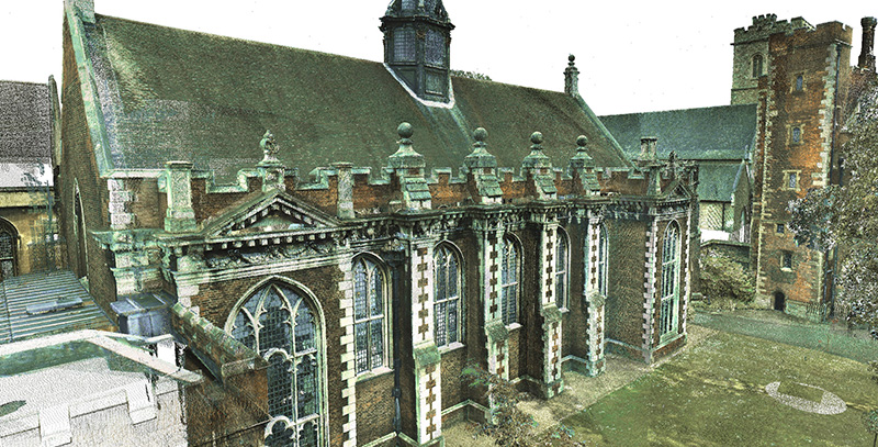
At MSA we understand that our measured surveys need to provide an integrated overview of existing site and building arrangements that will facilitate the wider usage of our 3D models by a multi-disciplinary team. Being able to translate these into different software programs and across platforms means that our clients can fully extract maximum value from our surveys. Using this approach the 3D models produced by MSA for architectural and engineering design are often also used for marketing, publicity, facilities management as well as a multitude of other applications.
We also provide 3D PDF and HTML files for those of our clients less familiar with technical applications of CAD programs.
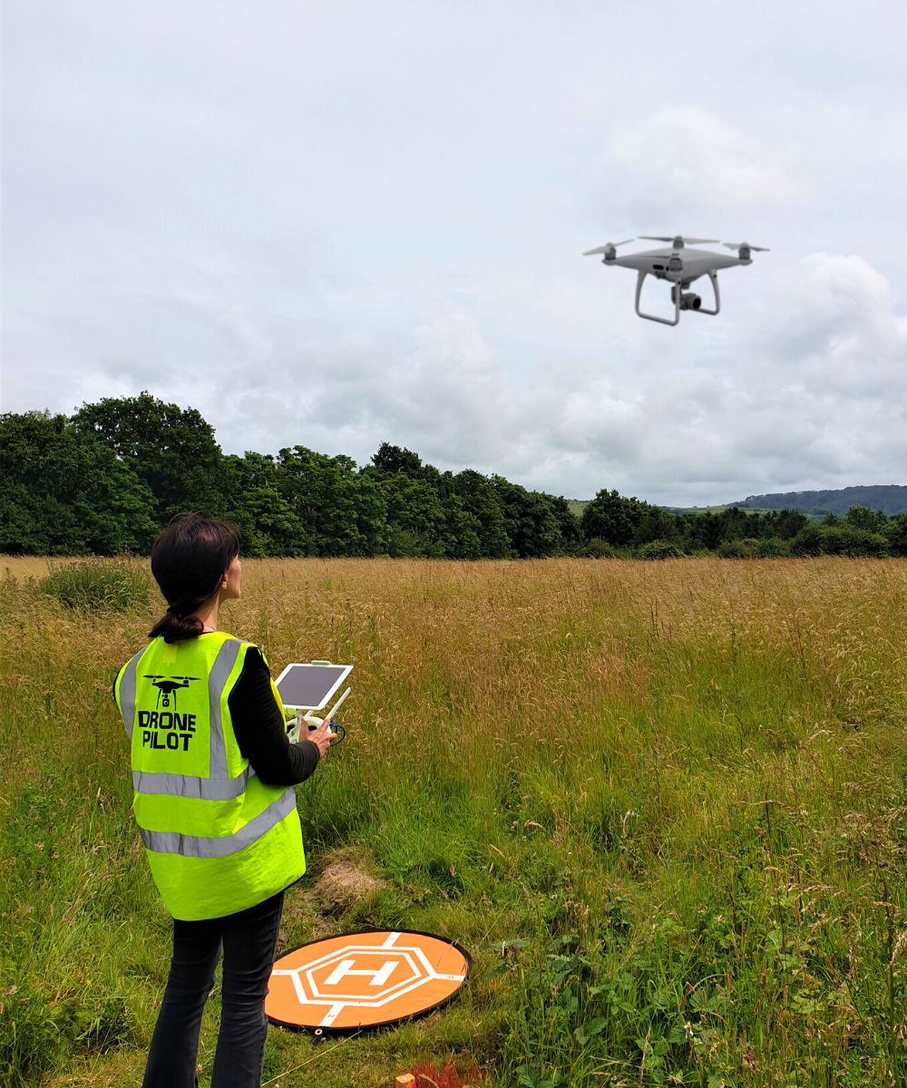
MSA Services are reaching new heights. UAV’s are a powerful new addition to the wide range of sophisticated equipment being used by MSA to capture and document the built environment. Having the ability to extend beyond the constraints of terrestrial based site measurement makes UAV’s an invaluable tool for the capture of accurate aerial mapping and 3D modelling.
Safety and compliance is at the heart of our professional UAV team, dedicated to using the latest technology in order to get our clients the most cost effective, precise results possible. However, it is our expertise as measured surveyors that truly allows us to extract the maximum benefit from the data obtained from our drones. This data is integrated with our ground based 3D laser scanning data and conventional survey measurements to ensure a level of accuracy and reliability that can only be achieved through a professional and experienced measured survey business.
We use our UAV for aerial mapping, topographic surveys, rights of right data capture, external 3D modelling, heritage documentation, condition surveys and scan to BIM solutions. We can deliver 2D plans and elevations as well as 3D models and high resolution imagery or video.
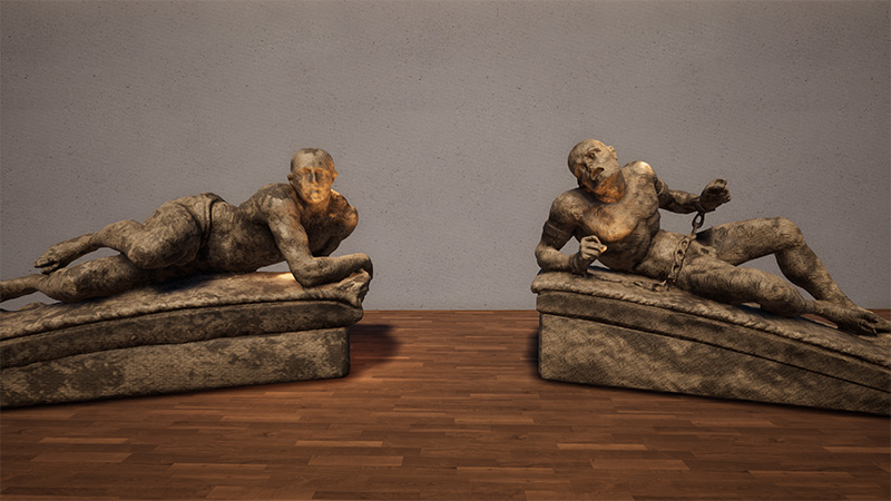
At MSA we are fully conversant in the capture, documentation and meshing of intricate artefacts, structures, features and objects to the highest level of detail for varying applications in order provide a concise and accurate virtual replica that can be manipulated within software packages. The use of scan data and 3D meshes is increasingly been seen as the preferred way of preserving the historic fabric and for applications within the film and animation industries.
The world architectural heritage is being lost at an alarming rate in our fast developing and modernising world. At MSA we are passionate about recording and documenting our past for future posterity and we strongly feel that we have a social responsibility to ensure that our culture and heritage are not lost for future generations.
Using laser scanners, measurements and high resolution imagery we are able to provide an accurate historic record which can be documented and safeguarded in a virtual environment for future use. This approach means that valuable assets can be recorded, reconstructed or reverse engineered should they be damage or destroyed and is invaluable for the conservation and restoration process.
MSA’s pioneering and immersive VR ready photography in the construction industry enables us to deliver an “out of the box” solution to compliment traditional 2D drawings and brings our survey projects to life. Now also being utilised by social media giants, and with a versatile and vast range of formats for delivery from standard resolution to full HDR and high resolution/large format, interactive 360° imagery is rapidly growing in popularity and is an invaluable asset for marketing, as well as offering new visual insights to design teams wherever they are located.
MSA also uses hi-resolution digital imagery to document current arrangements on site and to provide a historical record of site and building conditions. These form important data sources which is used by us in-house as well as shared with our consultant colleagues to enhance understanding and inform the design process.
They say “a picture paints a thousand words” and this is certainly the case when evaluating a proposed design. Photorealistic images can be generated from detailed 3D models to provide an accurate and authentic picture. When incorporating new designs these images can really bring a proposed scheme to life, allowing for the project to be viewed and interrogated in a realistic environment. Taking our detailed and accurate models a step further allows MSA to add textures, lighting and materials which enables us to authentically replicate reality within a virtual environment.
Video is a format that we are all very familiar with regardless of our background or expertise and provides an important link between architectural ideas or designs and their implementation. As a leader in 3D laser scan capture and the preparation of 3D models, MSA is able to extend these skills to provide an accurate virtual environment that is suitable for fly-through’s and can be used in the preparation of virtual tours and animation.
We set ourselves apart by applying objective and unconventional thinking to look beyond old habits and traditional measurement tools.
Fast turn-around of measured information gives you the edge in a highly competitive market
Comprehensive information capture provides a reliable project foundation your team can rely upon.
We can extract data quickly from scans without returning to site, minimising time, cost and disruption.
Capture of all site detail, from floorspace and ceiling heights to the number of telephone sockets and light fittings.
Make swift, informed decisions with our visual reports, photography, 3D models and plans.
We optimise financial return with solutions that meet tight timescales and budget requirements.
Memberships & Certifications
Team
Our passion, commitment and aptitude gives us a consistently progressive and creative approach to measurement.
Services

3D building models, digital twins, plans and reports to determine key structural and architectural elements, areas and layouts

The measurement and capture of topographic, terrain and boundary detail is a fundamental starting point for development.
The science of measurement and achievable tolerances makes us an invaluable partner for your engineering requirements.

Comprehensive and accurate 3D high definition (HD) scanning is at the core of all our services.
Memberships & Certifications